
Thank you for supporting this site ❤️
Make a donation
Make a donation
Gear up for your next adventure:
As an Amazon Associate, this site earns from qualifying purchases at no extra cost to you.
Jatiyoso topographic map
Click on the map to display elevation.
Thank you for supporting this site ❤️
Make a donation
Make a donation
Gear up for your next adventure:
As an Amazon Associate, this site earns from qualifying purchases at no extra cost to you.
About this map
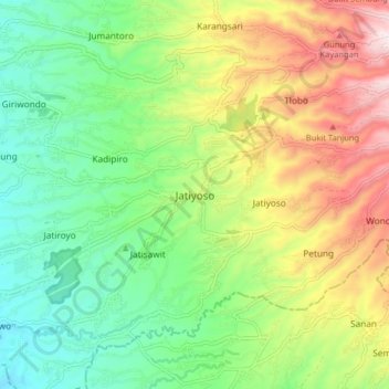
Name: Jatiyoso topographic map, elevation, terrain.
Location: Jatiyoso, Karanganyar, Central Java, Java, 57785, Indonesia (-7.76812 111.03057 -7.68812 111.11057)
Average elevation: 1,923 ft
Minimum elevation: 1,145 ft
Maximum elevation: 3,205 ft
Thank you for supporting this site ❤️
Make a donation
Make a donation
Gear up for your next adventure:
As an Amazon Associate, this site earns from qualifying purchases at no extra cost to you.