
Thank you for supporting this site ❤️
Make a donation
Make a donation
Gear up for your next adventure:
As an Amazon Associate, this site earns from qualifying purchases at no extra cost to you.
Júlia topographic map
Click on the map to display elevation.
Thank you for supporting this site ❤️
Make a donation
Make a donation
Gear up for your next adventure:
As an Amazon Associate, this site earns from qualifying purchases at no extra cost to you.
About this map
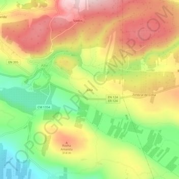
Name: Júlia topographic map, elevation, terrain.
Location: Júlia, Alte, Loulé, Faro, 8100-012, Portugal (37.21067 -8.18272 37.25067 -8.14272)
Average elevation: 774 ft
Minimum elevation: 243 ft
Maximum elevation: 1,289 ft
Thank you for supporting this site ❤️
Make a donation
Make a donation
Gear up for your next adventure:
As an Amazon Associate, this site earns from qualifying purchases at no extra cost to you.