Geolocate

Glenbrook topographic map

Click on the map to display elevation.

About this map

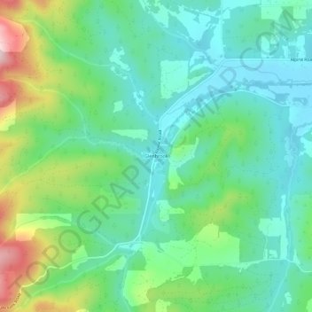
Name: Glenbrook topographic map, elevation, terrain.

Location: Glenbrook, Benton County, Oregon, United States (44.29373 -123.42649 44.33373 -123.38649)

Average elevation: 591 ft

Minimum elevation: 299 ft

Maximum elevation: 1,332 ft

Benton County trails, hiking, mountain biking, running and outdoor activities

Other topographic maps

Click on a map to view its topography, its elevation and its terrain.

Monroe

United States > Oregon > Benton County

Average elevation: 325 ft

Gear up for your next adventure:

🎒Gear Packing Cubes - Organize your backpack efficiently
🔥Fast-Boil Camping Stoves - Efficient cooking systems for quick trail meals
🔌Solar Panel Charger - Charge gear sustainably outdoors
🧣Merino Neck Gaiters - Multi-functional headwear for wind and sun protection
🕶️Glacier Sunglasses - Side shields to protect eyes from high-altitude snow glare

As an Amazon Associate, this site earns from qualifying purchases at no extra cost to you.