Geolocate

Monroe topographic map

Click on the map to display elevation.

About this map

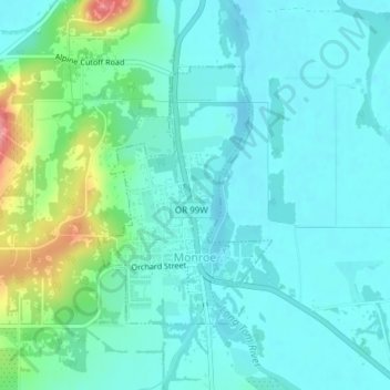
Name: Monroe topographic map, elevation, terrain.

Location: Monroe, Benton County, Oregon, United States (44.30988 -123.30691 44.32771 -123.28995)

Average elevation: 325 ft

Minimum elevation: 256 ft

Maximum elevation: 577 ft

Benton County trails, hiking, mountain biking, running and outdoor activities

Other topographic maps

Click on a map to view its topography, its elevation and its terrain.

Coast Range

United States > Oregon > Benton County

Average elevation: 2,703 ft

Kings Valley

United States > Oregon > Benton County

Average elevation: 410 ft

Hoskins

United States > Oregon > Benton County

Average elevation: 627 ft

Alpine

United States > Oregon > Benton County

Average elevation: 367 ft

Harris

United States > Oregon > Benton County

Average elevation: 843 ft

Lewisburg

United States > Oregon > Benton County

Average elevation: 331 ft

Glenbrook

United States > Oregon > Benton County

Average elevation: 591 ft

Noon

United States > Oregon > Benton County

Average elevation: 469 ft

Flynn

United States > Oregon > Benton County

Average elevation: 407 ft

Bellfountain

United States > Oregon > Benton County

Average elevation: 351 ft

Alder

United States > Oregon > Benton County

Average elevation: 801 ft

Blodgett

United States > Oregon > Benton County

Average elevation: 755 ft

Marys Peak

United States > Oregon > Benton County

Average elevation: 2,867 ft

Summit

United States > Oregon > Benton County

Average elevation: 715 ft

Gear up for your next adventure:

🩳Quick‑Dry Hiking Shorts - Comfortable and quick‑dry shorts for summer hiking
🧭Compass with Lanyard - Easy‑carry compass for navigation
🧺Microfiber Travel Towels - Compact and fast-drying towels for trail use
🥄Camping Utensil Set - Lightweight utensils for outdoor meals
☀️Outdoor Sunscreen - High protection sunscreen for outdoor activities

As an Amazon Associate, this site earns from qualifying purchases at no extra cost to you.