
Make a donation
Gear up for your next adventure:
As an Amazon Associate, this site earns from qualifying purchases at no extra cost to you.
Pic de Vallonpierre topographic map
Click on the map to display elevation.
Make a donation
Gear up for your next adventure:
As an Amazon Associate, this site earns from qualifying purchases at no extra cost to you.
About this map
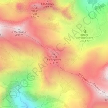
Name: Pic de Vallonpierre topographic map, elevation, terrain.
Average elevation: 7,989 ft
Minimum elevation: 5,896 ft
Maximum elevation: 9,442 ft
Make a donation
Gear up for your next adventure:
As an Amazon Associate, this site earns from qualifying purchases at no extra cost to you.
Other topographic maps
Click on a map to view its topography, its elevation and its terrain.
Chalet Hôtel Refuge du Gioberney
France > Provence-Alpes-Côte d'Azur > Hautes-Alpes > La Chapelle-en-Valgaudémar
Average elevation: 6,325 ft
Parc national des Écrins (cœur)
France > Provence-Alpes-Côte d'Azur > Hautes-Alpes > La Chapelle-en-Valgaudémar
Les années 1980 sont marquées par de grands travaux : le projet d'aménagement hydroélectrique de la haute-Romanche fait couler beaucoup d'encre en 1980, puis la sécurisation du lac d'Arsine (Briançonnais) à plus de 2 000 mètres d'altitude dès le printemps 1986. Enfin, en 1989, seize bouquetins sont…
Average elevation: 6,745 ft
Refuge de l'Olan
France > Provence-Alpes-Côte d'Azur > Hautes-Alpes > La Chapelle-en-Valgaudémar > Le Casset
Average elevation: 7,864 ft
Refuge du Clot - Xavier Blanc
France > Provence-Alpes-Côte d'Azur > Hautes-Alpes > La Chapelle-en-Valgaudémar > Le Rif du Sap
Average elevation: 5,896 ft
Make a donation
Gear up for your next adventure:
As an Amazon Associate, this site earns from qualifying purchases at no extra cost to you.
Refuge de Chabournéou
France > Provence-Alpes-Côte d'Azur > Hautes-Alpes > La Chapelle-en-Valgaudémar > Le Rif du Sap
Le refuge de Chabournéou se trouve dans le Valgaudemar, sur un promontoire rocheux sur les contreforts du Sirac, à 2 020 m d'altitude. L'accès se fait à pied, en 2 h, à partir d'un parking situé 500 mètres avant le chalet du Gioberney.
Average elevation: 7,536 ft