Geolocate

Port de Centuri topographic map

Click on the map to display elevation.

About this map
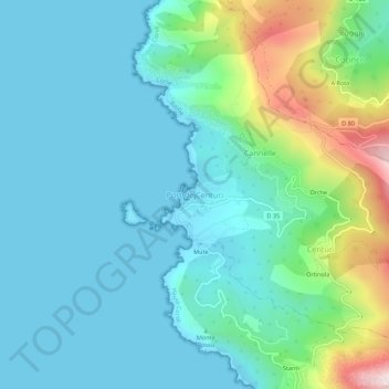
Name: Port de Centuri topographic map, elevation, terrain.

Location: Port de Centuri, Centuri, Bastia, Haute-Corse, Corsica, Metropolitan France, 20238, France (42.94616 9.33055 42.98616 9.37055)

Average elevation: 338 ft

Minimum elevation: 0 ft

Maximum elevation: 1,663 ft

Other topographic maps

Click on a map to view its topography, its elevation and its terrain.

Venaco

France > Corsica > Haute-Corse

Average elevation: 3,048 ft

Patrimonio

France > Corsica > Haute-Corse

Average elevation: 1,043 ft

Monte

France > Corsica > Haute-Corse

Average elevation: 1,480 ft

Ventiseri

France > Corsica > Haute-Corse

Average elevation: 1,096 ft

Le Fango

France > Corsica > Haute-Corse > Galéria

Average elevation: 1,998 ft

Casanova

France > Corsica > Haute-Corse

Average elevation: 2,454 ft

La Porta

France > Corsica > Haute-Corse > La Porta

Average elevation: 2,425 ft

Calacuccia

France > Corsica > Haute-Corse

Average elevation: 3,537 ft

Gear up for your next adventure:

🔥Plasma Lighters - Windproof lighters that work in any weather condition
🪶LED Camping Lantern - Bright lantern for camp lighting
📚Navigation Handbooks - Master the art of reading topographic maps and using a compass
⛺Backpacking Tent - Lightweight and durable tent for multi‑day hikes
📚USA Hiking Guide Books - Top trail guides and map books

As an Amazon Associate, this site earns from qualifying purchases at no extra cost to you.