
Make a donation
Gear up for your next adventure:
As an Amazon Associate, this site earns from qualifying purchases at no extra cost to you.
Montemor-o-Velho topographic map
Click on the map to display elevation.
Make a donation
Gear up for your next adventure:
As an Amazon Associate, this site earns from qualifying purchases at no extra cost to you.
Montemor-o-Velho
É sede de um município com 228,96km² de área e 26 171 habitantes (2011), subdividido em 11 freguesias. O município é limitado a norte pelo município de Cantanhede, a leste por Coimbra e por Condeixa-a-Nova, a sul por Soure e a oeste pela Figueira da Foz. Situa-se a uma altitude média de 5 m acima do nível médio do mar.
Make a donation
Gear up for your next adventure:
As an Amazon Associate, this site earns from qualifying purchases at no extra cost to you.
About this map
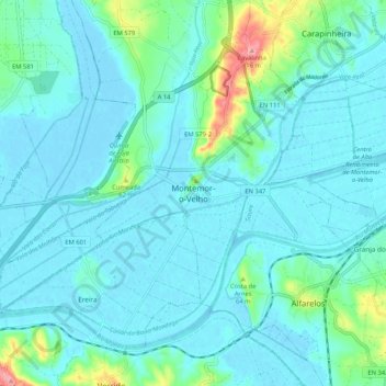
Name: Montemor-o-Velho topographic map, elevation, terrain.
Average elevation: 56 ft
Minimum elevation: -16 ft
Maximum elevation: 374 ft
Make a donation
Gear up for your next adventure:
As an Amazon Associate, this site earns from qualifying purchases at no extra cost to you.