Geolocate

playa topographic map

Click on the map to display elevation.

About this map

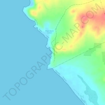
Name: playa topographic map, elevation, terrain.

Location: playa, Supe, Province of Barranca, Lima, Peru (-10.88245 -77.70172 -10.88180 -77.70137)

Average elevation: 56 ft

Minimum elevation: 0 ft

Maximum elevation: 249 ft

Other topographic maps

Click on a map to view its topography, its elevation and its terrain.

Caral

Peru > Lima > Supe

Average elevation: 1,532 ft

Caral

Peru > Lima > Supe

Average elevation: 1,532 ft

Caral

Peru > Lima > Supe

Average elevation: 1,532 ft

Sacred City of Caral-Supe

Peru > Lima > Supe > Caral

Average elevation: 1,289 ft

Caral

Peru > Lima > Supe

Average elevation: 1,532 ft

Gear up for your next adventure:

📷Action Camera - Capture your outdoor adventures in HD
🔭Compact Binoculars - HD vision for scouting terrain and identifying distant landmarks
🧭Map Reading Tools - Tools and kits for map navigation
🧦Hiking Socks - Comfortable socks to prevent blisters on long hikes
🥾Hiking Shoes - Durable and comfortable shoes for trail hiking

As an Amazon Associate, this site earns from qualifying purchases at no extra cost to you.