
Thank you for supporting this site ❤️
Make a donation
Make a donation
Gear up for your next adventure:
As an Amazon Associate, this site earns from qualifying purchases at no extra cost to you.
Tejutla topographic map
Click on the map to display elevation.
Thank you for supporting this site ❤️
Make a donation
Make a donation
Gear up for your next adventure:
As an Amazon Associate, this site earns from qualifying purchases at no extra cost to you.
About this map
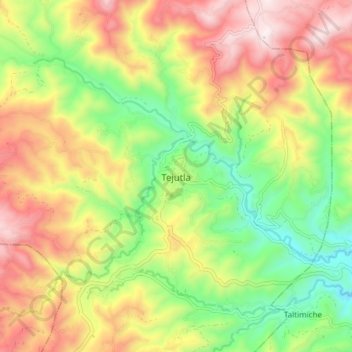
Name: Tejutla topographic map, elevation, terrain.
Location: Tejutla, San Marcos, Guatemala (15.08254 -91.84596 15.16254 -91.76596)
Average elevation: 8,343 ft
Minimum elevation: 7,129 ft
Maximum elevation: 9,734 ft
Thank you for supporting this site ❤️
Make a donation
Make a donation
Gear up for your next adventure:
As an Amazon Associate, this site earns from qualifying purchases at no extra cost to you.
Other topographic maps
Click on a map to view its topography, its elevation and its terrain.
Parque Regional Municipal Quetzalí
Guatemala > San Marcos > Tejutla > San Pedro Sacatepéquez > Aldea Buena Vista El Rosario
Average elevation: 9,984 ft