
Make a donation
Gear up for your next adventure:
As an Amazon Associate, this site earns from qualifying purchases at no extra cost to you.
Ordino topographic map
Click on the map to display elevation.
Make a donation
Gear up for your next adventure:
As an Amazon Associate, this site earns from qualifying purchases at no extra cost to you.
About this map
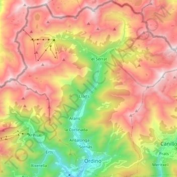
Name: Ordino topographic map, elevation, terrain.
Location: Ordino, AD300, Andorra (42.54585 1.46802 42.65594 1.60745)
Average elevation: 6,916 ft
Minimum elevation: 4,055 ft
Maximum elevation: 9,534 ft
Make a donation
Gear up for your next adventure:
As an Amazon Associate, this site earns from qualifying purchases at no extra cost to you.
Other topographic maps
Click on a map to view its topography, its elevation and its terrain.
Soldeu
The village is at an elevation of 1,710 metres (5,610 ft) above sea level and the top of the ski area is at 2,580 m (8,465 ft). The gondola from the village rises to 2,250 m (7,380 ft), where the ski and board schools as well as restaurants are located. From there, it is possible to ski to the top of the El…
Average elevation: 6,860 ft
Engolasters
Lake Engolasters, in the Encamp parish of Andorra, is an oblong shaped lake at an elevation of 1,616 m (5,302 ft). formed in a glacial depression. It is located close to Andorra La Vella, the capital of Andorra.
Average elevation: 5,223 ft
Andorra la Vella
The principal industry is tourism, although the country also earns foreign income from being a tax haven. Furniture and brandies are local products. Being at an elevation of 1,023 m (3,356 ft), it is the highest capital city in Europe and a popular ski resort. The city shares a tiny border area with Spain.
Average elevation: 5,315 ft
Pic de Comapedrosa
Coma Pedrosa, shaped like a pyramid, is situated at the northwestern border with France and Spain. It has in the past acted as a barrier between Andorra and France. The mountainous terrain of Andorra, a landlocked country, contains 65 peaks that rise to an elevation of greater than 2,000 m (6,562 ft). Coma…
Average elevation: 8,274 ft
Make a donation
Gear up for your next adventure:
As an Amazon Associate, this site earns from qualifying purchases at no extra cost to you.
Andorra la Vella
The principal industry is tourism, although the country also earns foreign income from being a tax haven. Furniture and brandies are local products. Being at an elevation of 1,023 m (3,356 ft), it is the highest capital city in Europe and a popular ski resort. The city shares a tiny border area with Spain.
Average elevation: 5,315 ft
Make a donation
Gear up for your next adventure:
As an Amazon Associate, this site earns from qualifying purchases at no extra cost to you.
Make a donation
Gear up for your next adventure:
As an Amazon Associate, this site earns from qualifying purchases at no extra cost to you.
Arinsal
Arinsal (Catalan pronunciation: [əɾinˈzal]) is a village in Andorra, set at an altitude of between 1550 and 2560 metres, close to the border with Spain at Tor, Pallars. In the summer Arinsal is home to walkers and bikers, as well as those who just want to relax in the mountain scenery. In the winter, it…
Average elevation: 6,089 ft
Pas de la Casa
Its name literally translates as "the pass of the house" and refers to the fact that until the early twentieth century there was only a single shepherd's hut overlooking the pass. The pass marks the watershed of the Pyrenees, being the only point in Andorra where water drains into the Atlantic Ocean, and is…
Average elevation: 7,530 ft
Pal
It is situated at an altitude of 1,551 m (5,089 ft). The village church, of the 11th century and in Romanesque style, is dedicated to St. Clement. It has a rectangular bell tower with mullioned windows decorated. Above the town, in the forest of Pal, in 1982 was inaugurated the ski resort of Pal, now grouped…
Average elevation: 6,004 ft
Soldeu
The village is at an elevation of 1,710 metres (5,610 ft) above sea level and the top of the ski area is at 2,580 m (8,465 ft). The gondola from the village rises to 2,250 m (7,380 ft), where the ski and board schools as well as restaurants are located. From there, it is possible to ski to the top of the El…
Average elevation: 6,860 ft
Make a donation
Gear up for your next adventure:
As an Amazon Associate, this site earns from qualifying purchases at no extra cost to you.
Arinsal
Arinsal (Catalan pronunciation: [aɾinˈzal]) is a village in Andorra, set at an altitude of between 1550 and 2560 metres, close to the border with Spain at Tor, Pallars. In the summer Arinsal is home to walkers and bikers, as well as those who just want to relax in the mountain scenery. In the winter, it…
Average elevation: 6,089 ft