
Conesus topographic map
Click on the map to display elevation.
About this map
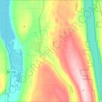
Name: Conesus topographic map, elevation, terrain.
Location: Conesus, Livingston County, New York, 14435, United States (42.67194 -77.71809 42.76368 -77.59952)
Average elevation: 1,273 ft
Minimum elevation: 801 ft
Maximum elevation: 1,952 ft
Livingston County trails, hiking, mountain biking, running and outdoor activities
Other topographic maps
Click on a map to view its topography, its elevation and its terrain.
Shaker Crossing
United States > New York > Livingston County > Town of Mount Morris
Average elevation: 594 ft
Sonyea State Forest
United States > New York > Livingston County > Town of Mount Morris
Average elevation: 758 ft