
Georgetown topographic map
Click on the map to display elevation.
About this map
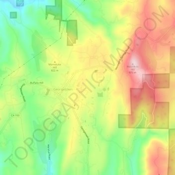
Name: Georgetown topographic map, elevation, terrain.
Location: Georgetown, El Dorado County, California, United States (38.88727 -120.85636 38.92728 -120.79718)
Average elevation: 2,625 ft
Minimum elevation: 2,077 ft
Maximum elevation: 3,209 ft
El Dorado County trails, hiking, mountain biking, running and outdoor activities
Other topographic maps
Click on a map to view its topography, its elevation and its terrain.