
Thank you for supporting this site ❤️
Make a donation
Make a donation
Gear up for your next adventure:
As an Amazon Associate, this site earns from qualifying purchases at no extra cost to you.
Fenghuang topographic map
Click on the map to display elevation.
Thank you for supporting this site ❤️
Make a donation
Make a donation
Gear up for your next adventure:
As an Amazon Associate, this site earns from qualifying purchases at no extra cost to you.
About this map
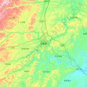
Name: Fenghuang topographic map, elevation, terrain.
Location: Fenghuang, Fenghuang County, Xiangxi, Hunan, 416200, China (27.79133 109.43420 28.11133 109.75420)
Average elevation: 1,385 ft
Minimum elevation: 492 ft
Maximum elevation: 3,353 ft
Thank you for supporting this site ❤️
Make a donation
Make a donation
Gear up for your next adventure:
As an Amazon Associate, this site earns from qualifying purchases at no extra cost to you.