Geolocate

Pastoriza topographic map

Click on the map to display elevation.

About this map

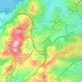
Name: Pastoriza topographic map, elevation, terrain.

Location: Pastoriza, Arteixo, La Coruña, Galicia, España (43.32272 -8.47724 43.35806 -8.43985)

Average elevation: 341 ft

Minimum elevation: 0 ft

Maximum elevation: 801 ft

Other topographic maps

Click on a map to view its topography, its elevation and its terrain.

O Igrexario

España > Galicia > La Coruña > Arteixo

Average elevation: 463 ft

O Monte Pequeno

España > Galicia > La Coruña > Arteixo

Average elevation: 197 ft

A Estación

España > Galicia > La Coruña > Arteixo

Average elevation: 482 ft

A Cachopa

España > Galicia > La Coruña > Arteixo

Average elevation: 217 ft

Corteo de Arriba

España > Galicia > La Coruña > Arteixo

Average elevation: 554 ft

Gomesende

España > Galicia > La Coruña > Arteixo

Average elevation: 469 ft

A Estación

España > Galicia > La Coruña > Arteixo

Average elevation: 482 ft

O Monte do Lobo

España > Galicia > La Coruña > Arteixo > O Puntido

Average elevation: 98 ft

Gear up for your next adventure:

🌲Outdoor Survival Books - Best books on survival skills
🪶Wildlife Field Guides - Learn animal tracking and species ID
🛶Inflatable Kayak - Portable kayak for rivers, lakes, and expeditions
🛠️Backpacking Tool Kit - Essential toolkit for outdoor repairs
🧦Hiking Socks - Comfortable socks to prevent blisters on long hikes

As an Amazon Associate, this site earns from qualifying purchases at no extra cost to you.