
Plimoth Commons topographic map
Click on the map to display elevation.
About this map
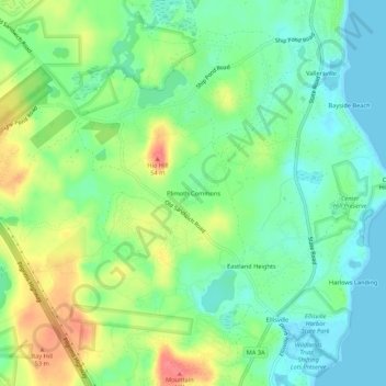
Name: Plimoth Commons topographic map, elevation, terrain.
Average elevation: 79 ft
Minimum elevation: 0 ft
Maximum elevation: 210 ft
Plymouth County trails, hiking, mountain biking, running and outdoor activities
Other topographic maps
Click on a map to view its topography, its elevation and its terrain.
Fresh Pond
United States > Massachusetts > Plymouth County > Plymouth > Cedar Bushes
Average elevation: 46 ft
Great Herring Pond
United States > Massachusetts > Plymouth County > Plymouth > Cedarville
Average elevation: 79 ft