
Make a donation
Gear up for your next adventure:
As an Amazon Associate, this site earns from qualifying purchases at no extra cost to you.
Seyssinet-Pariset topographic map
Click on the map to display elevation.
Make a donation
Gear up for your next adventure:
As an Amazon Associate, this site earns from qualifying purchases at no extra cost to you.
Seyssinet-Pariset
Ses habitants sont appelés les Seyssinettois. La mairie est située à 215 m d'altitude et le centre du hameau de Pariset est situé à 650 m d'altitude.
Make a donation
Gear up for your next adventure:
As an Amazon Associate, this site earns from qualifying purchases at no extra cost to you.
About this map
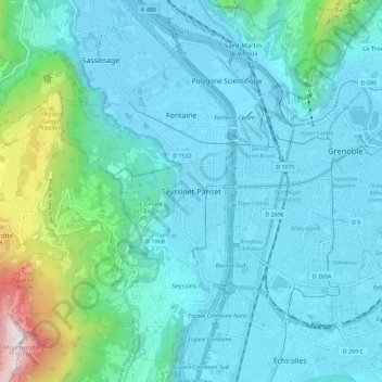
Name: Seyssinet-Pariset topographic map, elevation, terrain.
Average elevation: 1,457 ft
Minimum elevation: 659 ft
Maximum elevation: 6,198 ft
Make a donation
Gear up for your next adventure:
As an Amazon Associate, this site earns from qualifying purchases at no extra cost to you.
Other topographic maps
Click on a map to view its topography, its elevation and its terrain.
Avenue Hector Berlioz
France > Auvergne-Rhône-Alpes > Seyssinet-Pariset > Seyssinet-Pariset
Average elevation: 991 ft