
Make a donation
Gear up for your next adventure:
As an Amazon Associate, this site earns from qualifying purchases at no extra cost to you.
Morgan Territory topographic map
Click on the map to display elevation.
Make a donation
Gear up for your next adventure:
As an Amazon Associate, this site earns from qualifying purchases at no extra cost to you.
About this map
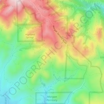
Name: Morgan Territory topographic map, elevation, terrain.
Average elevation: 1,470 ft
Minimum elevation: 919 ft
Maximum elevation: 2,188 ft
Contra Costa County trails, hiking, mountain biking, running and outdoor activities
Make a donation
Gear up for your next adventure:
As an Amazon Associate, this site earns from qualifying purchases at no extra cost to you.
Other topographic maps
Click on a map to view its topography, its elevation and its terrain.
Castle Hill
United States > California > Contra Costa County
Castle Hill is a census-designated place in Contra Costa County, California. Castle Hill sits at an elevation of 302 feet (92 m). The 2010 United States census reported Castle Hill's population was 1,299.
Average elevation: 308 ft
Make a donation
Gear up for your next adventure:
As an Amazon Associate, this site earns from qualifying purchases at no extra cost to you.
Make a donation
Gear up for your next adventure:
As an Amazon Associate, this site earns from qualifying purchases at no extra cost to you.
Make a donation
Gear up for your next adventure:
As an Amazon Associate, this site earns from qualifying purchases at no extra cost to you.
Stege
United States > California > Contra Costa County > Richmond
Stege, founded in 1876, was an unincorporated community in western Contra Costa County, California, United States. The town has now been annexed and absorbed by the cities of Richmond and El Cerrito, California. It was located on the Southern Pacific Railroad 1.5 miles (2.4 km) south-southeast of downtown…
Average elevation: 33 ft
Make a donation
Gear up for your next adventure:
As an Amazon Associate, this site earns from qualifying purchases at no extra cost to you.
Canyon
United States > California > Contra Costa County
Canyon, formerly known as Sequoya, is an unincorporated community located near the border of Contra Costa and Alameda counties, in the U.S. state of California. It is situated between Oakland and Moraga in the San Francisco Bay Area. The community is named for its location in the upper canyon of San Leandro…
Average elevation: 958 ft
Bayview-Montalvin
United States > California > Contra Costa County > Pinole > Gateley
Average elevation: 56 ft
Make a donation
Gear up for your next adventure:
As an Amazon Associate, this site earns from qualifying purchases at no extra cost to you.
Saranap
United States > California > Contra Costa County
Saranap (until 1913, Dewing Park) is a residential census-designated place (CDP) within central Contra Costa County, California. Lying at an elevation of 180 feet (55 m), it is bounded on the south and east by portions of Walnut Creek (including the gated senior residential development Rossmoor) and on the…
Average elevation: 302 ft
Make a donation
Gear up for your next adventure:
As an Amazon Associate, this site earns from qualifying purchases at no extra cost to you.
Make a donation
Gear up for your next adventure:
As an Amazon Associate, this site earns from qualifying purchases at no extra cost to you.
Make a donation
Gear up for your next adventure:
As an Amazon Associate, this site earns from qualifying purchases at no extra cost to you.
Wm Penn Mott Grove
United States > California > Contra Costa County > Moraga
Average elevation: 725 ft
Make a donation
Gear up for your next adventure:
As an Amazon Associate, this site earns from qualifying purchases at no extra cost to you.
Discovery Bay
United States > California > Contra Costa County > Discovery Bay
Average elevation: 0 ft
Make a donation
Gear up for your next adventure:
As an Amazon Associate, this site earns from qualifying purchases at no extra cost to you.
Make a donation
Gear up for your next adventure:
As an Amazon Associate, this site earns from qualifying purchases at no extra cost to you.
Lafayette Reservoir
United States > California > Contra Costa County > Lafayette
Average elevation: 571 ft
John Muir National Historic Site
United States > California > Contra Costa County > Martinez > Muir
Average elevation: 308 ft
Make a donation
Gear up for your next adventure:
As an Amazon Associate, this site earns from qualifying purchases at no extra cost to you.
Eugene O'Neill National Historic Site
United States > California > Contra Costa County > Alamo
Average elevation: 778 ft