Geolocate

Oujda topographic map

Click on the map to display elevation.

Oujda

The city is located 60 km (37 mi) south of the Mediterranean sea and 15 km (9 mi) west of Algeria, with an estimated altitude of 450 metres (1,476 feet).

Wikipedia (CC-BY-SA 3.0)

About this map

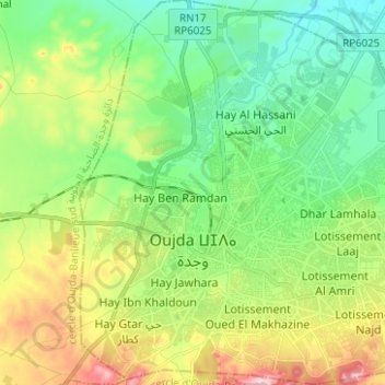
Name: Oujda topographic map, elevation, terrain.

Location: Oujda, Pachalik d'Oujda باشوية وجدة, Oujda-Angad Prefecture, Oriental, Morocco (34.64155 -1.96615 34.74415 -1.85167)

Average elevation: 1,857 ft

Minimum elevation: 1,594 ft

Maximum elevation: 2,379 ft

Gear up for your next adventure:

📖Nature Tracking Books - Learn to track wildlife and terrain
🧯Portable Fire Pit - Compact fire pit for camping spots
☀️Outdoor Sunscreen - High protection sunscreen for outdoor activities
📱Solar Portable Charger - Solar power bank for charging devices off‑grid
🌲Outdoor Survival Books - Best books on survival skills

As an Amazon Associate, this site earns from qualifying purchases at no extra cost to you.