
Make a donation
Gear up for your next adventure:
As an Amazon Associate, this site earns from qualifying purchases at no extra cost to you.
Unterbränd topographic map
Click on the map to display elevation.
Make a donation
Gear up for your next adventure:
As an Amazon Associate, this site earns from qualifying purchases at no extra cost to you.
About this map
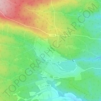
Name: Unterbränd topographic map, elevation, terrain.
Average elevation: 2,740 ft
Minimum elevation: 2,493 ft
Maximum elevation: 3,146 ft
Make a donation
Gear up for your next adventure:
As an Amazon Associate, this site earns from qualifying purchases at no extra cost to you.
Other topographic maps
Click on a map to view its topography, its elevation and its terrain.
Unterbränd
Deutschland > Baden-Württemberg > Schwarzwald-Baar-Kreis > Bräunlingen
Average elevation: 2,726 ft
78199
Deutschland > Baden-Württemberg > Schwarzwald-Baar-Kreis > Bräunlingen > Waldhausen
Average elevation: 2,549 ft
Döggingen
Deutschland > Baden-Württemberg > Schwarzwald-Baar-Kreis > Bräunlingen
Average elevation: 2,477 ft