
Make a donation
Gear up for your next adventure:
As an Amazon Associate, this site earns from qualifying purchases at no extra cost to you.
Johanneck topographic map
Click on the map to display elevation.
Make a donation
Gear up for your next adventure:
As an Amazon Associate, this site earns from qualifying purchases at no extra cost to you.
About this map
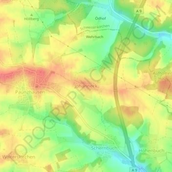
Name: Johanneck topographic map, elevation, terrain.
Average elevation: 1,617 ft
Minimum elevation: 1,506 ft
Maximum elevation: 1,706 ft
Make a donation
Gear up for your next adventure:
As an Amazon Associate, this site earns from qualifying purchases at no extra cost to you.
Other topographic maps
Click on a map to view its topography, its elevation and its terrain.
Freising
Deutschland > Bayern > Landkreis Freising
Im südwestlichen Gemeindegebiet liegt das Freisinger Moos, eines der größten noch erhaltenen Niedermoorgebiete Bayerns. Es hat sich dort entwickelt, wo die Schotterpakete der Münchner Ebene so dünn sind, dass die Grundwasserströme an die Oberfläche traten und ausgedehnte Niedermoore bildeten. In dem von…
Average elevation: 1,499 ft
Hollerner See
Deutschland > Bayern > Landkreis Freising > Eching > Am Geflügelhof
Average elevation: 1,549 ft
Make a donation
Gear up for your next adventure:
As an Amazon Associate, this site earns from qualifying purchases at no extra cost to you.
Neufahrn bei Freising
Deutschland > Bayern > Landkreis Freising
Der Hauptort Neufahrn liegt im Norden der Münchner Schotterebene in einer historischen Heidelandschaft und markiert den höchsten Punkt einer Schotterzunge, die bis zum Massenhausener Moos reicht. Nach Norden schließt sich das Freisinger Moos an. Die Landschaft um Neufahrn und Mintraching/Grüneck ist nahezu…
Average elevation: 1,522 ft
Make a donation
Gear up for your next adventure:
As an Amazon Associate, this site earns from qualifying purchases at no extra cost to you.
85413
Deutschland > Bayern > Landkreis Freising > Margarethenried > Sixt in der Point
Average elevation: 1,588 ft
Make a donation
Gear up for your next adventure:
As an Amazon Associate, this site earns from qualifying purchases at no extra cost to you.
Make a donation
Gear up for your next adventure:
As an Amazon Associate, this site earns from qualifying purchases at no extra cost to you.
Make a donation
Gear up for your next adventure:
As an Amazon Associate, this site earns from qualifying purchases at no extra cost to you.
Make a donation
Gear up for your next adventure:
As an Amazon Associate, this site earns from qualifying purchases at no extra cost to you.
Xaverienthal
Deutschland > Bayern > Landkreis Freising > Freising > Altenhausen
Average elevation: 1,539 ft
Make a donation
Gear up for your next adventure:
As an Amazon Associate, this site earns from qualifying purchases at no extra cost to you.
Make a donation
Gear up for your next adventure:
As an Amazon Associate, this site earns from qualifying purchases at no extra cost to you.
85419
Deutschland > Bayern > Landkreis Freising > Schwarzersdorf > Hartshausen bei Mauern
Average elevation: 1,552 ft
Moosburg
Deutschland > Bayern > Landkreis Freising
Moosburg liegt am nordöstlichsten Ende der Münchner Schotterebene am Übergang zum Donau-Isar-Hügelland sowie zum Isar-Inn-Hügelland. Während das alte Stadtzentrum sowie weitere Teile der Stadt auf einem tertiären Höhenzug zwischen der Isar und der nördlich der Stadt einmündenden Amper liegen, wird…
Average elevation: 1,404 ft
85354
Deutschland > Bayern > Landkreis Freising > Freising > Hohenbachern > Gartelshausen
Average elevation: 1,516 ft
Make a donation
Gear up for your next adventure:
As an Amazon Associate, this site earns from qualifying purchases at no extra cost to you.
Make a donation
Gear up for your next adventure:
As an Amazon Associate, this site earns from qualifying purchases at no extra cost to you.
Make a donation
Gear up for your next adventure:
As an Amazon Associate, this site earns from qualifying purchases at no extra cost to you.
Make a donation
Gear up for your next adventure:
As an Amazon Associate, this site earns from qualifying purchases at no extra cost to you.
Kammerberg
Deutschland > Bayern > Landkreis Freising
Das „Bürger Windrad Kammerberg“ ist ein Windrad vom Typ Enercon E-115 mit 149 Meter Nabenhöhe und einer Gesamthöhe von 207 Meter. Es wird betrieben von der Bürger Energie Genossenschaft – Freisinger Land eG. Es gibt noch Pläne für weitere Windräderturme zu bauen.
Average elevation: 1,591 ft
Make a donation
Gear up for your next adventure:
As an Amazon Associate, this site earns from qualifying purchases at no extra cost to you.
Make a donation
Gear up for your next adventure:
As an Amazon Associate, this site earns from qualifying purchases at no extra cost to you.
Troll
Deutschland > Bayern > Landkreis Freising > Moosburg
Auf alten topografischen Karten von 1890 befindet sich die Bezeichnung „Trollmühle“, die 1943 durch „Troll“ ersetzt wurde. Bis zum 1. Januar 1978 war Troll ein Ortsteil von Pfrombach, das dann nach Moosburg eingemeindet wurde.
Average elevation: 1,394 ft
Make a donation
Gear up for your next adventure:
As an Amazon Associate, this site earns from qualifying purchases at no extra cost to you.
Make a donation
Gear up for your next adventure:
As an Amazon Associate, this site earns from qualifying purchases at no extra cost to you.
Make a donation
Gear up for your next adventure:
As an Amazon Associate, this site earns from qualifying purchases at no extra cost to you.
Make a donation
Gear up for your next adventure:
As an Amazon Associate, this site earns from qualifying purchases at no extra cost to you.
Make a donation
Gear up for your next adventure:
As an Amazon Associate, this site earns from qualifying purchases at no extra cost to you.
Make a donation
Gear up for your next adventure:
As an Amazon Associate, this site earns from qualifying purchases at no extra cost to you.
Moosburg
Deutschland > Bayern > Landkreis Freising
Moosburg liegt am nordöstlichsten Ende der Münchner Schotterebene am Übergang zum Donau-Isar-Hügelland sowie zum Isar-Inn-Hügelland. Während das alte Stadtzentrum sowie weitere Teile der Stadt auf einem tertiären Höhenzug zwischen der Isar und der nördlich der Stadt einmündenden Amper liegen, wird…
Average elevation: 1,404 ft