
Thank you for supporting this site ❤️
Make a donation
Make a donation
Gear up for your next adventure:
As an Amazon Associate, this site earns from qualifying purchases at no extra cost to you.
Kafanchan topographic map
Click on the map to display elevation.
Thank you for supporting this site ❤️
Make a donation
Make a donation
Gear up for your next adventure:
As an Amazon Associate, this site earns from qualifying purchases at no extra cost to you.
About this map
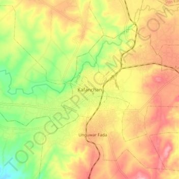
Name: Kafanchan topographic map, elevation, terrain.
Location: Kafanchan, Kafanchan A, Jema'A, Kaduna, Nigeria (9.54519 8.25261 9.62519 8.33261)
Average elevation: 2,431 ft
Minimum elevation: 2,198 ft
Maximum elevation: 2,618 ft
Thank you for supporting this site ❤️
Make a donation
Make a donation
Gear up for your next adventure:
As an Amazon Associate, this site earns from qualifying purchases at no extra cost to you.