Geolocate

Oswego topographic map

Click on the map to display elevation.

About this map

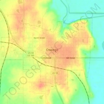
Name: Oswego topographic map, elevation, terrain.

Location: Oswego, Labette County, Kansas, 67356, United States (37.15574 -95.13604 37.17785 -95.09365)

Average elevation: 883 ft

Minimum elevation: 794 ft

Maximum elevation: 948 ft

Labette County trails, hiking, mountain biking, running and outdoor activities

Gear up for your next adventure:

🛡️Bear Spray Outdoor - Protection in bear country hikes
🎒Waterproof Dry Bags - Keep your electronics and maps dry inside your pack
🔪Outdoor Multitools - Essential survival tools for gear repair and field use
🧼Biodegradable Camping Soap - Eco‑friendly soap for outdoor hygiene
🪑Portable Camp Table - Compact table for campsite meals

As an Amazon Associate, this site earns from qualifying purchases at no extra cost to you.