Geolocate

Waimea topographic map

Click on the map to display elevation.

About this map

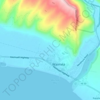
Name: Waimea topographic map, elevation, terrain.

Location: Waimea, Kauaʻi County, Hawaii, United States (21.95112 -159.69346 21.97617 -159.65528)

Average elevation: 194 ft

Minimum elevation: 0 ft

Maximum elevation: 988 ft

Kauaʻi County trails, hiking, mountain biking, running and outdoor activities

Gear up for your next adventure:

📡Handheld GPS Device - Reliable handheld GPS for outdoor navigation
📱Solar Portable Charger - Solar power bank for charging devices off‑grid
🥇GPS Hiking Watch - Multi‑sport GPS watch with navigation and trail tracking
🎒Day Hiking Backpack - Lightweight backpack perfect for day trips and outdoor adventures
🔭Compact Binoculars - HD vision for scouting terrain and identifying distant landmarks

As an Amazon Associate, this site earns from qualifying purchases at no extra cost to you.