
Thank you for supporting this site ❤️
Make a donation
Make a donation
Gear up for your next adventure:
As an Amazon Associate, this site earns from qualifying purchases at no extra cost to you.
Derna topographic map
Click on the map to display elevation.
Thank you for supporting this site ❤️
Make a donation
Make a donation
Gear up for your next adventure:
As an Amazon Associate, this site earns from qualifying purchases at no extra cost to you.
About this map
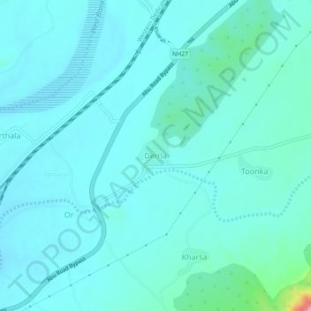
Name: Derna topographic map, elevation, terrain.
Location: Derna, Abu Road Tehsil, Sirohi, Rajasthan, 307510, India (24.49256 72.81511 24.53256 72.85511)
Average elevation: 935 ft
Minimum elevation: 869 ft
Maximum elevation: 1,404 ft
Thank you for supporting this site ❤️
Make a donation
Make a donation
Gear up for your next adventure:
As an Amazon Associate, this site earns from qualifying purchases at no extra cost to you.