
Make a donation
Gear up for your next adventure:
As an Amazon Associate, this site earns from qualifying purchases at no extra cost to you.
Le Recoin topographic map
Click on the map to display elevation.
Make a donation
Gear up for your next adventure:
As an Amazon Associate, this site earns from qualifying purchases at no extra cost to you.
Le Recoin
Chamrousse est une commune française située géographiquement en altitude dans les Alpes à l'extrémité sud de la chaîne de Belledonne, au-dessus de la vallée du Grésivaudan et de l'agglomération grenobloise, administrativement dans le département de l'Isère, en région Auvergne-Rhône-Alpes et autrefois rattachée à l'ancienne province du Dauphiné.
Make a donation
Gear up for your next adventure:
As an Amazon Associate, this site earns from qualifying purchases at no extra cost to you.
About this map
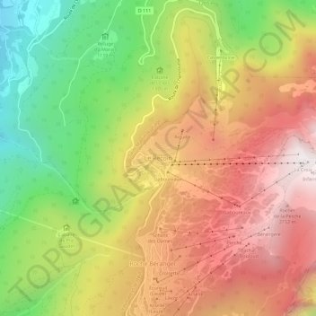
Name: Le Recoin topographic map, elevation, terrain.
Average elevation: 4,980 ft
Minimum elevation: 2,388 ft
Maximum elevation: 7,382 ft
Make a donation
Gear up for your next adventure:
As an Amazon Associate, this site earns from qualifying purchases at no extra cost to you.