Geolocate

Inca topographic map

Click on the map to display elevation.

About this map

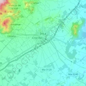
Name: Inca topographic map, elevation, terrain.

Location: Inca, Raiguer, Balearic Islands, 07300, Spain (39.67071 2.87818 39.75088 2.99970)

Average elevation: 410 ft

Minimum elevation: 164 ft

Maximum elevation: 2,054 ft

Other topographic maps

Click on a map to view its topography, its elevation and its terrain.

Gear up for your next adventure:

🧷Carabiner Set - Durable clips for gear attachment
🥩Freeze-Dried Meals - Nutritious and lightweight food for remote expeditions
🌎3D Topographic Globes - Raised relief globes for a tactile understanding of geography
⛑️Personal Locator Beacon - Safety beacon for emergencies
🧺Microfiber Travel Towels - Compact and fast-drying towels for trail use

As an Amazon Associate, this site earns from qualifying purchases at no extra cost to you.