
Souliers topographic map
Interactive map
Click on the map to display elevation.
About this map
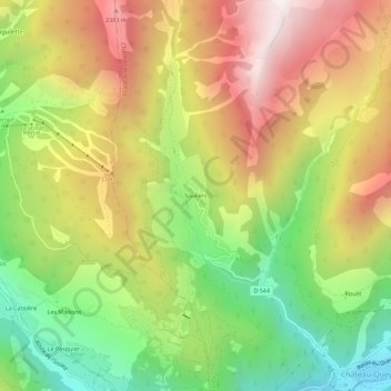
Name: Souliers topographic map, elevation, terrain.
Average elevation: 6,309 ft
Minimum elevation: 4,400 ft
Maximum elevation: 8,353 ft
Other topographic maps
Click on a map to view its topography, its elevation and its terrain.
Lac de Souliers
France > Provence-Alpes-Côte d'Azur > Hautes-Alpes > Château-Ville-Vieille
Average elevation: 7,989 ft