
Thank you for supporting this site ❤️
Make a donation
Make a donation
Gear up for your next adventure:
As an Amazon Associate, this site earns from qualifying purchases at no extra cost to you.
Ban Pha Mon topographic map
Click on the map to display elevation.
Thank you for supporting this site ❤️
Make a donation
Make a donation
Gear up for your next adventure:
As an Amazon Associate, this site earns from qualifying purchases at no extra cost to you.
About this map
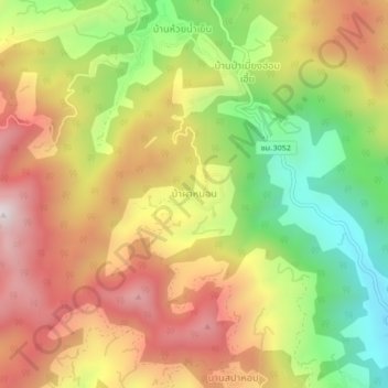
Name: Ban Pha Mon topographic map, elevation, terrain.
Location: Ban Pha Mon, Mae Taeng, Chiang Mai Province, Thailand (19.14472 98.78445 19.18472 98.82445)
Average elevation: 3,002 ft
Minimum elevation: 1,601 ft
Maximum elevation: 4,314 ft
Thank you for supporting this site ❤️
Make a donation
Make a donation
Gear up for your next adventure:
As an Amazon Associate, this site earns from qualifying purchases at no extra cost to you.
Other topographic maps
Click on a map to view its topography, its elevation and its terrain.