
Make a donation
Gear up for your next adventure:
As an Amazon Associate, this site earns from qualifying purchases at no extra cost to you.
Gaysville topographic map
Click on the map to display elevation.
Make a donation
Gear up for your next adventure:
As an Amazon Associate, this site earns from qualifying purchases at no extra cost to you.
About this map
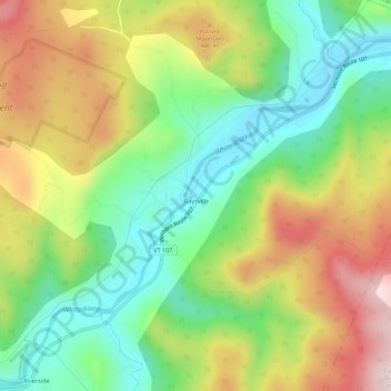
Name: Gaysville topographic map, elevation, terrain.
Average elevation: 1,181 ft
Minimum elevation: 584 ft
Maximum elevation: 2,008 ft
Make a donation
Gear up for your next adventure:
As an Amazon Associate, this site earns from qualifying purchases at no extra cost to you.
Other topographic maps
Click on a map to view its topography, its elevation and its terrain.
Make a donation
Gear up for your next adventure:
As an Amazon Associate, this site earns from qualifying purchases at no extra cost to you.
Norwich
United States > Vermont > Windsor County
The landscape is hilly and wooded. The elevation of the town center is 531 feet (162 m). The hills in the town include the 1,700-foot (520 m) Griggs Mountain in the southwestern section and the 1,853-foot (565 m) Gile Mountain in the northwestern section.
Average elevation: 948 ft
Make a donation
Gear up for your next adventure:
As an Amazon Associate, this site earns from qualifying purchases at no extra cost to you.
Proctorsville
United States > Vermont > Windsor County > Cavendish > Proctorsville
Average elevation: 1,165 ft
Make a donation
Gear up for your next adventure:
As an Amazon Associate, this site earns from qualifying purchases at no extra cost to you.
Make a donation
Gear up for your next adventure:
As an Amazon Associate, this site earns from qualifying purchases at no extra cost to you.
White River Junction
United States > Vermont > Windsor County > Hartford > White River Junction
Average elevation: 512 ft
Make a donation
Gear up for your next adventure:
As an Amazon Associate, this site earns from qualifying purchases at no extra cost to you.
West Windsor
United States > Vermont > Windsor County
The unincorporated village of Brownsville is one of the few urban areas in the town and sits at the northwestern base of Mount Ascutney (elevation 3143 ft.).
Average elevation: 1,201 ft
White River Junction
United States > Vermont > Windsor County > Hartford > White River Junction
Average elevation: 512 ft
Norwich
United States > Vermont > Windsor County
The landscape is hilly and wooded. The elevation of the town center is 531 feet (162 m). The hills in the town include the 1,700-foot (520 m) Griggs Mountain in the southwestern section and the 1,853-foot (565 m) Gile Mountain in the northwestern section.
Average elevation: 948 ft
Make a donation
Gear up for your next adventure:
As an Amazon Associate, this site earns from qualifying purchases at no extra cost to you.
Make a donation
Gear up for your next adventure:
As an Amazon Associate, this site earns from qualifying purchases at no extra cost to you.
Make a donation
Gear up for your next adventure:
As an Amazon Associate, this site earns from qualifying purchases at no extra cost to you.
North Springfield
United States > Vermont > Windsor County > Springfield
North Springfield is an unincorporated community and census-designated place in the town of Springfield, Windsor County, Vermont, United States. As of the 2010 census, the population of the CDP was 573. It lies at an altitude of 495 feet (151 m). A post office has been operated in North Springfield since 1832.…
Average elevation: 587 ft
Make a donation
Gear up for your next adventure:
As an Amazon Associate, this site earns from qualifying purchases at no extra cost to you.
Make a donation
Gear up for your next adventure:
As an Amazon Associate, this site earns from qualifying purchases at no extra cost to you.
Make a donation
Gear up for your next adventure:
As an Amazon Associate, this site earns from qualifying purchases at no extra cost to you.