Geolocate

Hofeck topographic map

Click on the map to display elevation.

About this map

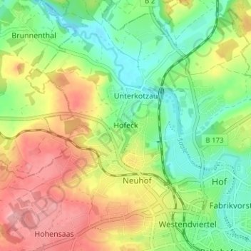
Name: Hofeck topographic map, elevation, terrain.

Location: Hofeck, Hof, Bayern, 95030, Deutschland (50.31092 11.87450 50.35092 11.91450)

Average elevation: 1,683 ft

Minimum elevation: 1,519 ft

Maximum elevation: 1,893 ft

Other topographic maps

Click on a map to view its topography, its elevation and its terrain.

95030

Deutschland > Bayern > Hof

Average elevation: 1,722 ft

95028

Deutschland > Bayern > Hof

Average elevation: 1,686 ft

Saale

Deutschland > Bayern > Hof > Unterkotzau

Average elevation: 1,657 ft

Gear up for your next adventure:

🧭Map Reading Tools - Tools and kits for map navigation
🥾Women's Hiking Boots - Top-rated trail boots with ankle support and superior grip
🛶Inflatable Kayak - Portable kayak for rivers, lakes, and expeditions
🪶LED Camping Lantern - Bright lantern for camp lighting
🎒Trekking Poles - Sturdy poles for balance and stability on rough terrain

As an Amazon Associate, this site earns from qualifying purchases at no extra cost to you.