
Make a donation
Gear up for your next adventure:
As an Amazon Associate, this site earns from qualifying purchases at no extra cost to you.
Melide topographic map
Click on the map to display elevation.
Make a donation
Gear up for your next adventure:
As an Amazon Associate, this site earns from qualifying purchases at no extra cost to you.
Melide
Melide (Spanish: Mellid) is a municipality in the province of A Coruña in the autonomous region of Galicia in northwest Spain. It belongs to the comarca of Terra de Melide. It has an area of 101 km2 and a population of 9,000 inhabitants mostly spread among its 26 parishes. It has an elevation of 456 meters.
Make a donation
Gear up for your next adventure:
As an Amazon Associate, this site earns from qualifying purchases at no extra cost to you.
About this map
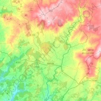
Name: Melide topographic map, elevation, terrain.
Location: Melide, Terra de Melide, A Coruña, Galicia, Spain (42.87503 -8.13486 42.99124 -7.93551)
Average elevation: 1,654 ft
Minimum elevation: 840 ft
Maximum elevation: 2,618 ft
Make a donation
Gear up for your next adventure:
As an Amazon Associate, this site earns from qualifying purchases at no extra cost to you.
Other topographic maps
Click on a map to view its topography, its elevation and its terrain.