
Hunedoara topographic map
Interactive map
Click on the map to display elevation.
About this map
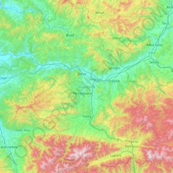
Name: Hunedoara topographic map, elevation, terrain.
Location: Hunedoara, Romania (45.23835 22.33601 46.35267 23.60168)
Average elevation: 2,329 ft
Minimum elevation: 456 ft
Maximum elevation: 8,054 ft
Other topographic maps
Click on a map to view its topography, its elevation and its terrain.
Peana
Romania > Cluj > Cluj-Napoca
Peana, Cluj-Napoca, Cluj Metropolitan Area, Cluj, 407271, Romania
Average elevation: 2,431 ft
Mărtinești
Mărtinești, Tureni, Cluj Metropolitan Area, Cluj, 407563, Romania
Average elevation: 1,919 ft
Dorolea
Dorolea, Livezile, Bistrița-Năsăud, 427122, Romania
Average elevation: 1,601 ft
Carpathian Mountains
Carpathian Mountains, Toplița, Harghita, 535705, Romania
Average elevation: 3,215 ft