
Târnăveni topographic map
Interactive map
Click on the map to display elevation.
About this map
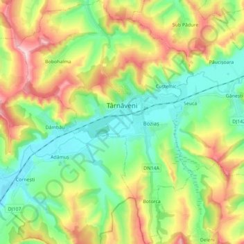
Name: Târnăveni topographic map, elevation, terrain.
Location: Târnăveni, Mureș, Romania (46.26129 24.20527 46.38111 24.33108)
Average elevation: 1,220 ft
Minimum elevation: 896 ft
Maximum elevation: 1,785 ft
Other topographic maps
Click on a map to view its topography, its elevation and its terrain.
Oarba de Mureș
Oarba de Mureș, Iernut, Mureș, 545104, Romania
Average elevation: 1,086 ft
Transylvania
Transylvania, Band, Mureș, 547065, Romania
Average elevation: 2,126 ft
Ideciu de Sus
Ideciu de Sus, Ideciu de Jos, Mureș, 547362, Romania
Average elevation: 1,385 ft
Bistra
Romania > Mureș > Bistra Mureșului
Bistra, Bistra Mureșului, Deda, Mureș, 547206, Romania
Average elevation: 2,451 ft
Târgu Mureș
Târgu Mureș, Targu Mures Metropolitan Area, Mureș, Romania
Average elevation: 1,171 ft
Sântana de Mureș
Romania > Mureș > Sântana de Mureș
Sântana de Mureș, Targu Mures Metropolitan Area, Mureș, Romania
Average elevation: 1,201 ft