
Make a donation
Gear up for your next adventure:
As an Amazon Associate, this site earns from qualifying purchases at no extra cost to you.
Modena topographic map
Click on the map to display elevation.
Make a donation
Gear up for your next adventure:
As an Amazon Associate, this site earns from qualifying purchases at no extra cost to you.
About this map
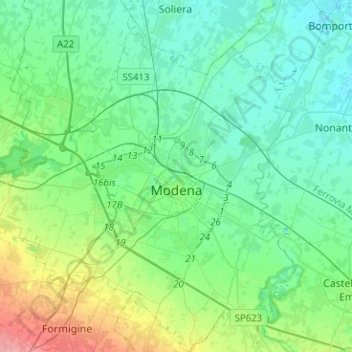
Name: Modena topographic map, elevation, terrain.
Location: Modena, Emilia-Romagna, Italy (44.56295 10.78208 44.74244 11.01227)
Average elevation: 131 ft
Minimum elevation: 69 ft
Maximum elevation: 341 ft
Make a donation
Gear up for your next adventure:
As an Amazon Associate, this site earns from qualifying purchases at no extra cost to you.
Other topographic maps
Click on a map to view its topography, its elevation and its terrain.
Make a donation
Gear up for your next adventure:
As an Amazon Associate, this site earns from qualifying purchases at no extra cost to you.
Monte Cimone
Italy > Emilia-Romagna > Modena > Fiumalbo
The mountain has an elevation of 2,165 m and is also the highest point in the Emilia-Romagna region of Italy.
Average elevation: 5,771 ft
Savignano sul Panaro
Italy > Emilia-Romagna > Modena > Savignano sul Panaro > Savignano sul Panaro
Average elevation: 443 ft