Geolocate

Monte Cimone topographic map

Click on the map to display elevation.

Monte Cimone

The mountain has an elevation of 2,165 m and is also the highest point in the Emilia-Romagna region of Italy.

Wikipedia (CC-BY-SA 3.0)

About this map

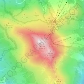
Name: Monte Cimone topographic map, elevation, terrain.

Location: Monte Cimone, Fiumalbo, Unione dei comuni del Frignano, Modena, Emilia-Romagna, Italy (44.19362 10.70023 44.19372 10.70033)

Average elevation: 5,771 ft

Minimum elevation: 4,649 ft

Maximum elevation: 7,064 ft

Gear up for your next adventure:

🛶Inflatable Kayak - Portable kayak for rivers, lakes, and expeditions
🔋Solar Power Banks - Keep your GPS and phone charged in remote wilderness areas
🗻Climbing Gear Basics - Essential gear for beginner climbers
🛡️Insect Repellent - Protection against bugs during outdoor activities
🧭Compass with Lanyard - Easy‑carry compass for navigation

As an Amazon Associate, this site earns from qualifying purchases at no extra cost to you.