
Make a donation
Gear up for your next adventure:
As an Amazon Associate, this site earns from qualifying purchases at no extra cost to you.
Horse Shoe topographic map
Click on the map to display elevation.
Make a donation
Gear up for your next adventure:
As an Amazon Associate, this site earns from qualifying purchases at no extra cost to you.
About this map
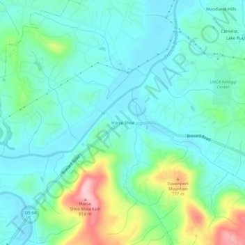
Name: Horse Shoe topographic map, elevation, terrain.
Average elevation: 2,192 ft
Minimum elevation: 2,037 ft
Maximum elevation: 2,697 ft
Henderson County trails, hiking, mountain biking, running and outdoor activities
Make a donation
Gear up for your next adventure:
As an Amazon Associate, this site earns from qualifying purchases at no extra cost to you.
Other topographic maps
Click on a map to view its topography, its elevation and its terrain.
Mills River
United States > North Carolina > Henderson County > Mills River > Oak Hill Court
Average elevation: 2,077 ft
Echo Lake
United States > North Carolina > Henderson County > Laurel Park > Country Ridge
Average elevation: 2,493 ft
Mills River
United States > North Carolina > Henderson County > Mills River
Average elevation: 2,251 ft
Make a donation
Gear up for your next adventure:
As an Amazon Associate, this site earns from qualifying purchases at no extra cost to you.
Barker Heights
United States > North Carolina > Henderson County > Barker Heights
Average elevation: 2,110 ft
East Flat Rock
United States > North Carolina > Henderson County > Ridgeview Estates
Average elevation: 2,149 ft
Kanuga Lake
United States > North Carolina > Henderson County > Kanuga Ridge
Average elevation: 2,356 ft
Make a donation
Gear up for your next adventure:
As an Amazon Associate, this site earns from qualifying purchases at no extra cost to you.
Mills River
United States > North Carolina > Henderson County > Mills River > Oak Hill Court
Average elevation: 2,113 ft