
Gravesville topographic map
Interactive map
Click on the map to display elevation.
About this map
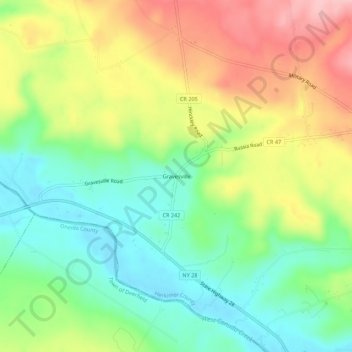
Name: Gravesville topographic map, elevation, terrain.
Average elevation: 919 ft
Minimum elevation: 696 ft
Maximum elevation: 1,224 ft
Other topographic maps
Click on a map to view its topography, its elevation and its terrain.
Trenton Falls - Main Dam
United States > New York > Herkimer County > Town of Russia
Trenton Falls - Main Dam, Town of Russia, Herkimer County, New York, 13435, United States
Average elevation: 1,053 ft
Northwood
United States > New York > Herkimer County > Town of Russia
Northwood, Town of Russia, Herkimer County, New York, United States
Average elevation: 1,286 ft
Wheelertown
United States > New York > Herkimer County > Town of Russia
Wheelertown, Town of Russia, Herkimer County, New York, United States
Average elevation: 1,391 ft
Grant
United States > New York > Herkimer County > Town of Russia
Grant, Town of Russia, Herkimer County, New York, United States
Average elevation: 1,293 ft