Geolocate

Webb Summit topographic map

Click on the map to display elevation.

About this map

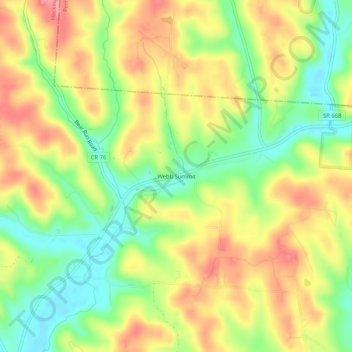
Name: Webb Summit topographic map, elevation, terrain.

Location: Webb Summit, Hocking County, Ohio, United States (39.56646 -82.38182 39.60646 -82.34182)

Average elevation: 886 ft

Minimum elevation: 732 ft

Maximum elevation: 1,037 ft

Hocking County trails, hiking, mountain biking, running and outdoor activities

Other topographic maps

Click on a map to view its topography, its elevation and its terrain.

Murray City

United States > Ohio > Hocking County

Average elevation: 843 ft

Rose Lake

United States > Ohio > Hocking County

Average elevation: 968 ft

Logan

United States > Ohio > Hocking County

Average elevation: 833 ft

Rose Lake Dam

United States > Ohio > Hocking County

Average elevation: 974 ft

Gear up for your next adventure:

🖼️Topo Map Wall Art - Decorative topographic prints of famous peaks and regions
🧯Portable Fire Pit - Compact fire pit for camping spots
📷Action Camera - Capture your outdoor adventures in HD
📚Navigation Handbooks - Master the art of reading topographic maps and using a compass
🧷Carabiner Set - Durable clips for gear attachment

As an Amazon Associate, this site earns from qualifying purchases at no extra cost to you.