Geolocate

Table Rock topographic map

Click on the map to display elevation.

About this map

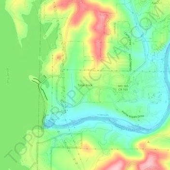
Name: Table Rock topographic map, elevation, terrain.

Location: Table Rock, Branson, Taney County, Missouri, 65516, United States (36.58479 -93.31879 36.62479 -93.27879)

Average elevation: 912 ft

Minimum elevation: 686 ft

Maximum elevation: 1,276 ft

Other topographic maps

Click on a map to view its topography, its elevation and its terrain.

Gear up for your next adventure:

📡Handheld GPS Device - Reliable handheld GPS for outdoor navigation
🪶Survival Guide Book - Expert advice for emergency preparedness
🦶Hiking Gaiters - Keep debris and water out of your boots
🗺️NatGeo Topo Maps - High-quality waterproof printed topographic maps of US Parks
🪑Portable Camp Table - Compact table for campsite meals

As an Amazon Associate, this site earns from qualifying purchases at no extra cost to you.