
Cupang topographic map
Click on the map to display elevation.
About this map
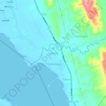
Name: Cupang topographic map, elevation, terrain.
Location: Cupang, Santo Tomas, La Union, Ilocos Region, Philippines (16.24083 120.37712 16.28083 120.41712)
Average elevation: 75 ft
Minimum elevation: -3 ft
Maximum elevation: 538 ft
Other topographic maps
Click on a map to view its topography, its elevation and its terrain.
Agoo-Damortis Protected Landscape and Seascape
Philippines > La Union > Santo Tomas
Average elevation: 30 ft