
Thank you for supporting this site ❤️
Make a donation
Make a donation
Gear up for your next adventure:
As an Amazon Associate, this site earns from qualifying purchases at no extra cost to you.
Pusuchisi topographic map
Click on the map to display elevation.
Thank you for supporting this site ❤️
Make a donation
Make a donation
Gear up for your next adventure:
As an Amazon Associate, this site earns from qualifying purchases at no extra cost to you.
About this map
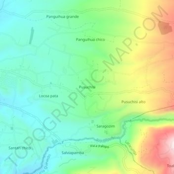
Name: Pusuchisi topographic map, elevation, terrain.
Location: Pusuchisi, Juan Montalvo, Latacunga, Cotopaxi, Ecuador (-0.94785 -78.57758 -0.90785 -78.53758)
Average elevation: 9,879 ft
Minimum elevation: 9,321 ft
Maximum elevation: 11,040 ft
Thank you for supporting this site ❤️
Make a donation
Make a donation
Gear up for your next adventure:
As an Amazon Associate, this site earns from qualifying purchases at no extra cost to you.
Other topographic maps
Click on a map to view its topography, its elevation and its terrain.