
Thank you for supporting this site ❤️
Make a donation
Make a donation
Gear up for your next adventure:
As an Amazon Associate, this site earns from qualifying purchases at no extra cost to you.
Dondaicha topographic map
Click on the map to display elevation.
Thank you for supporting this site ❤️
Make a donation
Make a donation
Gear up for your next adventure:
As an Amazon Associate, this site earns from qualifying purchases at no extra cost to you.
About this map
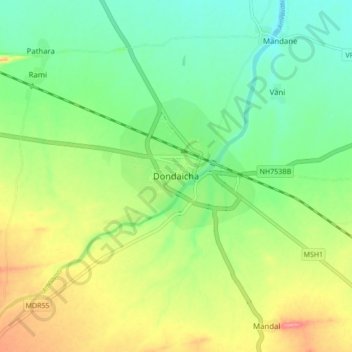
Name: Dondaicha topographic map, elevation, terrain.
Location: Dondaicha, Sindkhede, Dhule, Maharashtra, 425408, India (21.28562 74.52120 21.36562 74.60120)
Average elevation: 548 ft
Minimum elevation: 440 ft
Maximum elevation: 715 ft
Thank you for supporting this site ❤️
Make a donation
Make a donation
Gear up for your next adventure:
As an Amazon Associate, this site earns from qualifying purchases at no extra cost to you.