Geolocate

Hana topographic map

Click on the map to display elevation.

About this map

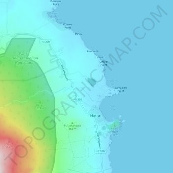
Name: Hana topographic map, elevation, terrain.

Location: Hana, Maui County, Hawaii, United States (20.73960 -156.01193 20.79295 -155.97677)

Average elevation: 256 ft

Minimum elevation: -3 ft

Maximum elevation: 1,949 ft

Maui County trails, hiking, mountain biking, running and outdoor activities

Gear up for your next adventure:

🧭GPS Watch Accessories - Bands and chargers for GPS watches
🛌Ultralight Sleeping Bags - Compact down bags for cold nights in the wilderness
📚Navigation Handbooks - Master the art of reading topographic maps and using a compass
🌧️Backpack Rain Cover - Keep gear dry in wet weather
🌡️Handheld Weather Meters - Measure wind, temp, and pressure for safe mountain travel

As an Amazon Associate, this site earns from qualifying purchases at no extra cost to you.