
Make a donation
Gear up for your next adventure:
As an Amazon Associate, this site earns from qualifying purchases at no extra cost to you.
Sunbury topographic map
Click on the map to display elevation.
Make a donation
Gear up for your next adventure:
As an Amazon Associate, this site earns from qualifying purchases at no extra cost to you.
About this map
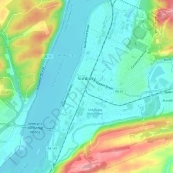
Name: Sunbury topographic map, elevation, terrain.
Average elevation: 541 ft
Minimum elevation: 404 ft
Maximum elevation: 883 ft
Northumberland County trails, hiking, mountain biking, running and outdoor activities
Make a donation
Gear up for your next adventure:
As an Amazon Associate, this site earns from qualifying purchases at no extra cost to you.
Other topographic maps
Click on a map to view its topography, its elevation and its terrain.
Dalmatia
United States > Pennsylvania > Northumberland County > Lower Mahanoy Township
Average elevation: 564 ft
Ranshaw
United States > Pennsylvania > Northumberland County > Coal Township
Average elevation: 1,073 ft
Dalmatia
United States > Pennsylvania > Northumberland County > Lower Mahanoy Township
Average elevation: 564 ft
Overlook
United States > Pennsylvania > Northumberland County > Ralpho Township
Average elevation: 856 ft
Make a donation
Gear up for your next adventure:
As an Amazon Associate, this site earns from qualifying purchases at no extra cost to you.
Dalmatia
United States > Pennsylvania > Northumberland County > Lower Mahanoy Township
Average elevation: 564 ft
Snufftown
United States > Pennsylvania > Northumberland County > Ralpho Township
Average elevation: 705 ft
Atlas
United States > Pennsylvania > Northumberland County > Mount Carmel Township
Average elevation: 1,263 ft