Geolocate

Doom Dooma topographic map

Click on the map to display elevation.

About this map

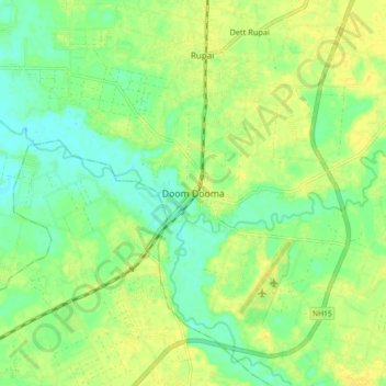
Name: Doom Dooma topographic map, elevation, terrain.

Location: Doom Dooma, Tinsukia, Assam, 786151, India (27.52998 95.51395 27.60998 95.59395)

Average elevation: 420 ft

Minimum elevation: 384 ft

Maximum elevation: 449 ft

Gear up for your next adventure:

📡GPS Antenna Upgrade - Enhance GPS reception in remote terrain
🧢Outdoor Hiking Hat - Sun protection hat for outdoor explorers
🧭Compass with Lanyard - Easy‑carry compass for navigation
🔊Portable Camp Speaker - Music and alerts at camp
🛌Ultralight Sleeping Bags - Compact down bags for cold nights in the wilderness

As an Amazon Associate, this site earns from qualifying purchases at no extra cost to you.