
Reisbach topographic map
Interactive map
Click on the map to display elevation.
About this map
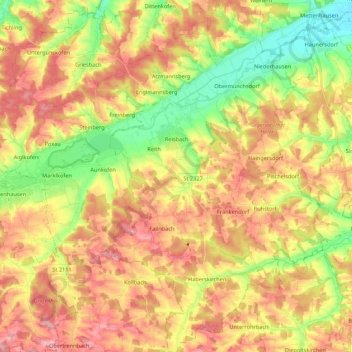
Name: Reisbach topographic map, elevation, terrain.
Location: Reisbach, Landkreis Dingolfing-Landau, Bavaria, 94419, Germany (48.48196 12.52611 48.62484 12.71720)
Average elevation: 1,453 ft
Minimum elevation: 1,214 ft
Maximum elevation: 1,673 ft
Other topographic maps
Click on a map to view its topography, its elevation and its terrain.
Oberdaching
Germany > Bavaria > Landkreis Dingolfing-Landau > Pilsting
Oberdaching, Pilsting, Landkreis Dingolfing-Landau, Bavaria, Germany
Average elevation: 1,309 ft
Pilsting
Germany > Bavaria > Landkreis Dingolfing-Landau
Pilsting, Landkreis Dingolfing-Landau, Bavaria, 94431, Germany
Average elevation: 1,188 ft
Hartkirchen
Germany > Bavaria > Landkreis Dingolfing-Landau
Hartkirchen, Eichendorf, Landkreis Dingolfing-Landau, Bavaria, 94574, Germany
Average elevation: 1,234 ft
Dingolfing
Germany > Bavaria > Landkreis Dingolfing-Landau
Dingolfing, Landkreis Dingolfing-Landau, Bavaria, 84130, Germany
Average elevation: 1,371 ft