Geolocate

Pilsting topographic map

Click on the map to display elevation.

About this map

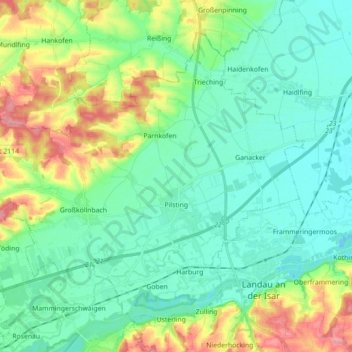
Name: Pilsting topographic map, elevation, terrain.

Location: Pilsting, Landkreis Dingolfing-Landau, Bavaria, 94431, Germany (48.66280 12.53777 48.75828 12.71473)

Average elevation: 1,188 ft

Minimum elevation: 1,079 ft

Maximum elevation: 1,470 ft

Other topographic maps

Click on a map to view its topography, its elevation and its terrain.

Wimbach

Germany > Bavaria > Landkreis Dingolfing-Landau > Reisbach

Average elevation: 1,473 ft

Ettling

Germany > Bavaria > Landkreis Dingolfing-Landau

Average elevation: 1,184 ft

Oberdaching

Germany > Bavaria > Landkreis Dingolfing-Landau > Pilsting

Average elevation: 1,309 ft

Hartkirchen

Germany > Bavaria > Landkreis Dingolfing-Landau

Average elevation: 1,234 ft

Gear up for your next adventure:

🔌USB Car Charger - Car charger for on‑the‑go power needs
⛑️Personal Locator Beacon - Safety beacon for emergencies
🔋Solar Power Banks - Keep your GPS and phone charged in remote wilderness areas
🌄Hiking Binoculars - Compact binoculars for scenic views and trail spotting
🧦Merino Wool Socks - Moisture-wicking, blister-preventing socks for long treks

As an Amazon Associate, this site earns from qualifying purchases at no extra cost to you.