Geolocate
👉 Easily get elevation data in JSON, GeoTIFF and KML formats using Elevation API
Thank you for supporting this site ❤️
Make a donation

Gear up for your next adventure:

As an Amazon Associate, this site earns from qualifying purchases at no extra cost to you.

Destin topographic map

Click on the map to display elevation.

Gear up for your next adventure:

As an Amazon Associate, this site earns from qualifying purchases at no extra cost to you.

About this map

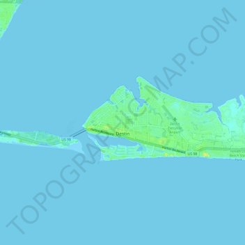
Name: Destin topographic map, elevation, terrain.

Location: Destin, Okaloosa County, Florida, 32540, United States (30.37863 -86.51588 30.41778 -86.39723)

Average elevation: 3 ft

Minimum elevation: -7 ft

Maximum elevation: 72 ft

Okaloosa County trails, hiking, mountain biking, running and outdoor activities

👉 Easily get elevation data in JSON, GeoTIFF and KML formats using Elevation API
Thank you for supporting this site ❤️
Make a donation

Gear up for your next adventure:

As an Amazon Associate, this site earns from qualifying purchases at no extra cost to you.

Other topographic maps

Click on a map to view its topography, its elevation and its terrain.

Dana Point

United States > Florida > Okaloosa County > Niceville

Average elevation: 7 ft

Holt

United States > Florida > Okaloosa County

Average elevation: 174 ft

Ocean City

United States > Florida > Okaloosa County > Ocean City

Average elevation: 20 ft

Deerland

United States > Florida > Okaloosa County

Average elevation: 207 ft

Gear up for your next adventure:

📱Solar Portable Charger - Solar power bank for charging devices off‑grid
🧢Sun Protection Hats - Wide-brimmed and UPF-rated hats for high-altitude sun safety
🌡️Portable Weather Meter - Track weather conditions on the trail

As an Amazon Associate, this site earns from qualifying purchases at no extra cost to you.