
Make a donation
Gear up for your next adventure:
As an Amazon Associate, this site earns from qualifying purchases at no extra cost to you.
Okonoko topographic map
Click on the map to display elevation.
Make a donation
Gear up for your next adventure:
As an Amazon Associate, this site earns from qualifying purchases at no extra cost to you.
Okonoko
Okonoko is positioned at an elevation of 173 metres (568 ft). The unincorporated community of Little Cacapon is located approximately 1.7 miles (2.7 km) east of Okonoko, the unincorporated community of Levels is located approximately 3.1 miles (5.0 km) to its southwest, and the town of Paw Paw is located approximately 3.5 miles (5.6 km) to its east. Okonoko is accessible from Levels, Little Cacapon, and Paw Paw via Okonoko Road. The Chesapeake and Ohio Canal and the Chesapeake and Ohio Canal National Historical Park are located directly across the Potomac River from Okonoko, in Maryland.
Make a donation
Gear up for your next adventure:
As an Amazon Associate, this site earns from qualifying purchases at no extra cost to you.
About this map
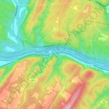
Name: Okonoko topographic map, elevation, terrain.
Average elevation: 823 ft
Minimum elevation: 489 ft
Maximum elevation: 1,214 ft
Hampshire County trails, hiking, mountain biking, running and outdoor activities
Make a donation
Gear up for your next adventure:
As an Amazon Associate, this site earns from qualifying purchases at no extra cost to you.
Other topographic maps
Click on a map to view its topography, its elevation and its terrain.