
Vaygach polar station topographic map
Interactive map
Click on the map to display elevation.
About this map
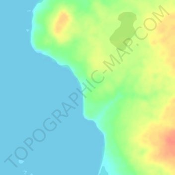
Name: Vaygach polar station topographic map, elevation, terrain.
Average elevation: 39 ft
Minimum elevation: 0 ft
Maximum elevation: 128 ft
Vaygach Island is mainly formed of argillaceous slates, sandstone, and limestone. There are many rivers about 20–40 kilometres (12–25 mi) in length, swamps, and small lakes on the island. For the most part it consists of tundra. Slight rocky ridges run generally along its length, and the coast has low cliffs in places. The island consists mostly of limestone, and its elevation above the sea is geologically recent. Raised beaches are frequent. The rocks are heavily scored by ice, but this was probably marine ice, not that of glaciers. The only settlement on the island is Varnek.